Special Thanks to WxWorx for sponsoring my trip by providing live onboard XM weather
Click HERE to track me using Air Traffic Control
Click my airplane for a larger view of my internal GPS tracker

Click HERE to see my detailed Itinerary (updated 6/28/09)

ARRIVING AT MILLION AIR IN ALBANY at 6PM 7/31/09

SEE my Final Route Map for the stats

Sunday, April 26, 2009

Just Landed at Albany

Wow, great view of Albany on final approach! Now fueling up for the
short flight home to Renssealer County.

Live from 3000 feet

Flying home from Long Island. Touchdown at 7pm.

Saturday, April 25, 2009

Lessons learned

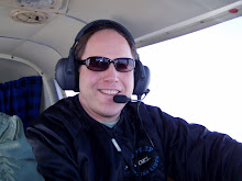
Well, yesterday's "dry run" gave me a few data points on the technical front for the blog. I had a 20 knot tailwind at 7500 feet, so I decided to stay there. When I am flying above 7500 ft, apparently I'm invisible to my tracking system. I am using an iPhone with some GPS software which uploads my current coordinates to Instamapper. Technically, I shouldn't be using a cell phone in flight, even in my own private plane, but it is only sending out a data point every 30 seconds. Gotta love justifications. Anyway, at 7500 ft, while the line of sight signal strength is probably great, the phone is either beyond the digital radius prescribed by the cell site or is just seeing too many sites and therefore can't send data.

So, in addition to me trying to track myself, air traffic control is also tracking me by tail number, at least when I'm using their services. I usually do avail myself of their services either for IFR flights or for VFR flight following, where they are giving me advisories concerning other traffic in the area. When they are tracking me, oftentimes you can track my airplane using their data which can be viewed in realtime (5 minute delay?) at Flightaware.com. It's a very useful site because it is tracking general aviation and commercial aviation, so you can track your commercial flights here as well. I may add this map to the blog page as well as backup.

The other technical glitch from yesterday was that I uploaded a blog entry from my phone just before I left and somehow it didn't make it on the blog. This is the entry regarding my takeoff from Rensselaer County airport. I had to resend it later. So, despite the fact that it appeared to upload properly, I guess I need to double-check that it actually made it.

T minus 36 days and counting.

Friday, April 24, 2009

Ready for Takeoff

Takeoff in 10 minutes from the Rensselaer County Airport. Begin to
refresh and the map should update soon. Off to Long Island.

Live from 7500 feet

Just leveled off at 7500 feet. Nice 20 knot tailwind. GPS indicates
touchdown at Mattitick in Long Island at 5:45pm.

Wednesday, April 22, 2009

GPS Tracking dry run on Friday at 4:30pm

On Friday, I will be flying to Long Island to see Pete Spaeth's daughter Veronica perform in Les Miserables. I will be leaving Hudson Valley Community College promptly at 4pm, driving to the airport by 4:15pm and taking off by 4:30pm. The flight will take approximately 1hr 15mins, so I should be airborne from 4:30pm - 5:45pm on Friday. I will be testing the GPS tracking through the blog, so if you load up the page, you should see me flying on the map in real time. If you click on the image of my airplane, it will bring up a much bigger map. Unfortuntely, it doesn't update automatically, so if you want to refresh my position, you will have to hit refresh on your browser. Try it out and see if it works for you.

I have also added two maps at the bottom of the page. For now, I have added a rough cut for my proposed route. It will run clockwise, starting on the east coast first. As I refine the route over the next several weeks, I will be updating that map. Below it will be the actual route flown. This will get updated based on the actual airports I land at along the way. Once the plan is in place, I don't expect too many changes, but on a trip like this, one should expect the unexpected I suppose. These maps are important so that you can really get a sense of the locations I'll be flying to within the US. I'll spend most of my time along the periphery of the country.

So, if you're bored on Friday, load up the page and track me live to Long Island.

T minus 40 days and counting.

Tuesday, April 21, 2009

Wow - GPS Tracking, Blog, and Twitter Feed on one page

Ok, so I'm little bit behind the curve on this whole Web 2.0 phenomenon, but I'm catching up. This is the first real Blog I've ever published and that's something that folks have been doing for years now (that's centuries in Internet time). I joined Facebook a few years ago and only within the last 6 months has my account gone crazy now that everyone in my age group jumped on the bandwagon. Also, everyone's had been talking about Twitter and I thought, why the heck do I need to be on yet another social networking site. I'm not that social to begin with :) Well, in putting this blog together, I now see a convergence of technologies and see the real benefit of Twitter in this context. The blog itself is the place for me to write a long-winded diatribe like this one and post videos and pictures. But it takes some effort to compose the thoughts that go into a blog entry. Enter Twitter - From my cell phone I can microblog or just quickly type (in a 140 characters or less) what is going on at that very moment and perhaps attach one photo. There's definitely a place for that, and for me, it appears on the right-hand column of this blog. So, I can compose long-winded blog entry like this one, or just type a quick message about what's happening, and either way, it appears on this page! What I love about this is that I can give one website out and people don't have to chase down all of the different social networking sites I use. In addition, I have a GPS tracking application for my cellphone and was able to add a live map at the top of this page. Hitting refresh will update my position if I'm moving. Also, clicking on the airplane photo will bring up a much bigger live map. You'll be tracking my airplane in flight!

So, now I have a way to communicate with all 2 of the people that are interested in what I'm doing. Hahaha. Anyway, I'm just excited to have found a medium that mashes all of the technologies I want to use to document this cross-country adventure I'm embarking on. I love the fact that I will be documenting the trip in real-time, people can keep track of exactly where I am and what I'm up to, and that the blog will then be an archive I look back to later.

Monday, April 20, 2009

42 days to go

42 days to go! I'm installing new seats, the airplane goes in for service on May 17th and I'll be blasting off on June 1st. I will be posting a detailed itinerary soon. Please contact me if you'd like me to stop in at an airport near you.

I've been planning this trip for 3 years and it will finally happen this year. I will be on the road, I mean in the air, for 2 full months exploring the United States. I love flying, but I also look forward to reconnecting with old friends, some of whom I haven't seen in 20 years! I hope to chronicle my experiences along the way here on the blog each day. In addition, I will be posting photographs and you can track me in realtime through the map above. I am also going to work on the capability to upload video.

To me, this is the ultimate adventure - aviation, freedom in the sky, meeting friends, and discovering places I've never been to before. More to follow!